Simplifying GPS Tracks
ComputingGPS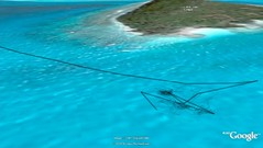 Anchoring
Originally uploaded by sharkbait.
Anchoring
Originally uploaded by sharkbait.
In my last post I talked about needing a tool to simplify GPS tracks, to remove the spikes and squiggles you get from inaccuracies in the GPS readings and stuff like swinging around on anchor chains.
Here is an image from Google Earth showing us anchoring. There are two tracks, one containing the full data, one showing the simplified data.
I think together they show quite well how a boat moves over time on an anchor.
I simplified the track using gpsbabel :
gpsbabel -i gpx -f 20070806.gpx -x position,distance=6m -o gpx -F 20070806-dist-6.gpx
This gets gpsbabel to filter the track, removing points that are closer than 6 meters together.
I went through a bunch of different distances, 6 meters gave me the most pleasing results, but the correct distance is probably going to be related to your speed.
This filtering makes almost no difference to the shape of the main track curve, only to the heavily crowded parts of the track where we were close to stationary.